Rich Petroleum Source Rocks
An inventory of petroleum source rocks in the World’s major sedimentary basins show that six geological intervals in Earth’s history generated over 90% of the World’s conventional oil and gas discoveries.
 Marcellus Shale is a petroliferous black shale deposited during the Devonian in eastern USA. It is also explored as a shale gas resource. This photo shows an outcrop of the Marcellus in New York State. Photo: Vaughn ThompsonDistribution of major petroleum sources rocks in space and through time has important implications for the global budget of petroleum resources. Although there is evidence for non-organic origin of methane, the majority of scientists consider oil and gas found in sedimentary basins to be products of organic-rich sediments.
Several independent studies have demonstrated that rich source rocks are largely concentrated in several stratigraphic intervals during the Phanerozoic (the past 542 million years). Such unequal distribution of source rocks in the geological record is apparent both on a global scale and in a given sedimentary basin.
These major stratigraphic intervals in Earth’s history are as follows (the ages are from the 2004 Geologic Timescale):
- Silurian (444-416 Ma)
- Late Devonian (385-360 Ma)
- Pennsylvanian-Late Permian (318-270)
- Late Jurassic (165-145)
- Middle Cretaceous (125-89 Ma)
- Oligocene-Miocene (34-5 Ma)
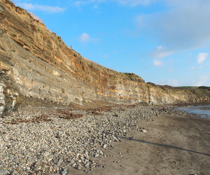 Upper Jurassic shales dominate as a source rock in the Northwest European sedimentary basins, and as much as 25% of the world’s conventional hydrocarbons may come from this interval. The type locality of the Kimmeridge Clay Formation is along the Dorset coast of England. Photo: Jane WhaleyThat all these time intervals fall within the Phanerozoic should not be surprising because life forms became extremely abundant and diversified during this eon (and this point itself renders support for the organic-origin theory of petroleum in sedimentary basins), but the fact that these six intervals, amounting to only 34% of Phanerozoic time, account for more than 90% of the world’s known oil and gas resources begs an explanation.
For one thing, these “highs” in the stratigraphic record are not regular “pulses” caused by a single recurring factor in Earth’s history. Detailed considerations rather show that the explanation lies in a combination of geological factors operating in specific regions and periods, and favoring the deposition and preservation of effective source rocks. Unfolding the complexity of these factors is a daunting task as we do not have detailed and comprehensive data necessary to quantify a given factor in every case. Nonetheless, it is informative to consider the major causes and first-order patterns in the geologic record to tackle this important issue.
Back to the Middle Paleozoic
Major Silurian source rocks occur in the Middle East, North Africa, and the USA (the Permian, Anadarko, and Michigan basins). Except for the carbonates of the intracratonic Michigan basin, the Silurian source rocks are mainly graptolite-rich black shales deposited on marine platforms. They have charged the Silurian-Permian clastic-carbonate reservoirs in the Middle East, the Paleozoic-Triassic sandstones in North Africa, and the Silurian carbonates in the USA. The Silurian source rocks contain mainly kerogen types I and II. Natural gas, however, constitutes a major part of hydrocarbon generated from these rocks, partly because of their deep burial to gas generation window (150-200° C).
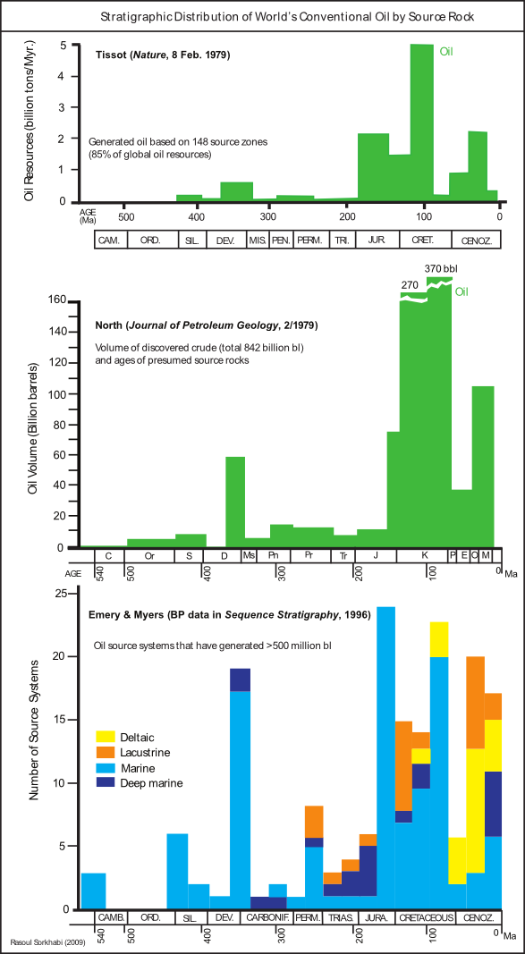 Three studies showing the distribution of the world’s conventional oil source rocks in the stratigraphic record. Illustration: Rasoul SorkhabiAfter the terminal Ordovician mass extinction, marine organisms, such as brachiopods, graptolites, ostrochods, conodonts, crinoids, and corals became abundant in the broad, shallow waters of the Silurian, and vascular plants began to inhabit marshy environments. Overall, the Silurian experienced a warm climate and high sea-level stand. These conditions favored deposition of black shales especially close to the sites of marine upwelling currents characterized by nutrient-rich waters and high organic productivity. One such example is the Lower Silurian Qusaiba “hot shale” in central Saudi Arabia, which was deposited in the shallow waters of Proto-Tethys.
During the Silurian, the northern margin of Gondwana, including the Middle East and North Africa, was under shallow marine (Proto-Tethys) conditions at latitudes between 30-60° South. Laurentia (North America and Greenland) and Baltica (Northern Europe) and the intervening Iapetus Ocean were then situated between 30° S and the Equator. In North America, the ancestral Appalachian mountains, which had formed during the Ordovician Taconic orogeny, were worn down in the Silurian forming extensive clastic sediments capped by carbonates and reef assemblages as sea level rose.
In many ways, the Devonian was a continuation of the Silurian although sea levels and global temperatures fell slightly. An important tectonic activity during the Devonian was the Acadian-Caledonian orogeny following the disappearance of the southern Iapetus Ocean and collision of Baltica with Laurentia. This collision produced the Caledonian mountains in Greenland, Scandinavia, and the British Isles, and rejuvenated the Appalachians in eastern USA. The Old Red Sandstone represents the freshwater clastic sediments of this orogeny.
Carbon isotope analyses of Devonian sediments indicate numerous anoxic events (oxygen-deficient sedimentation) during this period. Atmospheric circulation models superimposed on Devonian paleogeographic maps (Judith Parrish, AAPG Bulletin, June 1982) show major upwelling zones in many parts of the world during this period. The Lower Devonian Marcellus shale in Pennsylvania and the Upper Devonian Bakken shale in the Williston basin of the USA are remarkable examples of black shales deposited under these conditions.
Devonian shales and marls deposited on shallow marine platforms contained kerogen types I and II, and generated considerable amounts of oil that has filled Devonian-Carboniferous reservoirs. These source rocks occur in North America (Alberta, Williston, Permian, Anadarko, Michigan, Illinois, and Appalachian basins), South America (Amazon and Bolivia), North Africa (Algeria), Eastern Europe, and the Ural basins.
In Australia, however, Devonian source rocks (for example, in the Great Barrier Reef of the Canning Basin) contain kerogen type III (plant-derived) that generated natural gas in this region.
Into the Late Paleozoic
During the Pennsylvanian (Late Carboniferous)-Early Permian, the world entered cold climates with severe marine regressions (sea-level drops) globally, and glaciations in parts of Gondwana that then lay between the South Pole and 60° South – tillites (glacial deposits) of these glacial ages are preserved in Australia, India, and southern parts of Africa and Southern America. Nonetheless, during these periods Earth also enjoyed wide-spread forests and swamps: Conifers appeared in Siberia in the northern hemisphere, lycopods (such as club-mosses) were abundant in the tropical supercontinent of Laurentia-Baltica, and ferns were dominant in the southern cool supercontinent of Gondwana. That is why, thick coal beds are found in the Carboniferous (Mississippian-Pennsylvanian) and Permian strata in many parts of the world. (The name “Carboniferous” was given in reference to these “Coal Forests” in Europe, and the world’s oldest coal deposits come from this period). Therefore, Late Paleozoic source rocks are rich in kerogen type III and coaly material, and have generated considerable gas accumulated in Permian-Triassic reservoirs.
 Two studies of the distribution of the world’s conventional oil and gas source rocks in the stratigraphic record. Illustration: Rasoul SorkhabiThe Late Paleozoic gas plays are found in the US Mid-Continent (Williston to Permian) basins, the Appalachian basins, the southern parts of the North Sea, the northern Caspian-Ural basins of Russia, China, Australia, and southeast Africa. The age-equivalent rocks in the US Rockies and parts of the British Isles are, however, oil-prone shales as they largely contain liptinite (belonging to kerogen type II).
An important factor for the Late Paleozoic gas and oil accumulations around the world is the presence of evaporite cap rocks within Permian sediments; for example, the evaporties of the Rotliegend and Zechstein formations in the North Sea basins. These evaporites formed due to the drying of climates during the Late Permian.
In contrast to the Middle Paleozoic source rocks, which were largely deposited on open marine shelves, most of the Late Paleozoic source rocks were deposited in foreland basins created by continental collision of Gondwana (its northern margin) with Laurentia-Baltica (producing the Alleghanian or final Appalachians in eastern USA, the Hercynian or Variscan belt in Europe, and the Mauritanian mountains in northwest Africa), collision of Kazakhstania with Siberia (to form the Altai belt), and collision of Siberia with Laurentia (along the Ural belt). These collisional events gave rise to the supercontinent Pangea at the end of the Permian.
The Permian coals and shales in Australia, India, and southeast Africa, on the other hand, were deposited (or at least preserved) in rift basins as southern parts of Gondwana experienced extensional tectonics during the Permian.
Jurassic-Cretaceous Times
More than two-thirds of the known petroleum resources were generated by Jurassic-Cretaceous source rocks, making these periods a special case to consider. Because the dinosaurs also ruled the Jurassic and Cretaceous worlds, in the early decades of the twentieth century it became a popular geological idea that the death and burial of the dinosaurs created much of the world’s oil. We now know that our mighty oil resources (in the Jurassic-Cretaceous as in the other periods) owe their origin to tiny plankton, and that the dinosaurs consumed a lot more organic matter than they ever contributed to sediments. Indeed, the Cretaceous (Latin, “chalky”) was so named because of abundant calcium carbonate sediments made up of the shells of calcareous nanoplankton of that period.
From the Late Jurassic to the close of the Cretaceous, Earth entered a greenhouse world with warm climates and high sea levels. During these periods, plankton radiated profusely (calcareous nanoplankton and planktonic foraminifera as well as diatoms and rudists all appeared in the Jurassic), marine transgressions increased the world’s sediment budget, and anoxic events and upwelling currents enriched the organic content of marine sediments. All these events were responsible for the rich Upper Jurassic to Middle Cretaceous source rocks. Interestingly, during Late Jurassic-Cretaceous times, Pangea was fragmented and its new continents drifted apart, forming the present oceans on their trails. These continental breakups and ocean-floor generation all resulted in extensive volcanism that was probably responsible for the Cretaceous global warming, high sea levels, and widespread marine sedimentation. (Some scientists, notably John Larson, invoke a mantle superplume beneath the Pacific to explain these mid-Cretaceous events; see Mid-Cretaceous Source Rock Enigma)

Chronology of various geologic events in the Phanerozoic with implications for petroleum source rocks. Compiled from various sources by Rasoul Sorkhabi
Middle-Upper Jurassic source rocks are mainly found in the Middle East (Hanifa-Naokelkan-Sargelu-Dukhan formations), the Caspian region (various formation names), West Siberia (Bazhenov Formation), North Sea (Kimmeridgian Clay), and Gulf of Mexico (Haynesville Shale). These rocks are predominantly marine shale and marly limestone with kerogen types II and III, and have charged Upper Jurassic to Cretaceous oil and gas reservoirs in the basins where they occur.
Mid-Cretaceous source rocks are widely spread in basins around the world, but may be categorized into four major tectonostratigraphic groups: (1) Neo-Tethys shelf sediments in Asia and Europe, (2) passive-margin rift-drift sediments of Gondwana continents, (3) the Cretaceous seaway and foreland basin rocks of the North American and South American Cordillera, and (4) West Siberia. These source rocks consist of marine shales and marly limestones with kerogen types II and III, and have generated Upper Cretaceous-Paleogene-Miocene oil and gas accumulations in their respective basins.
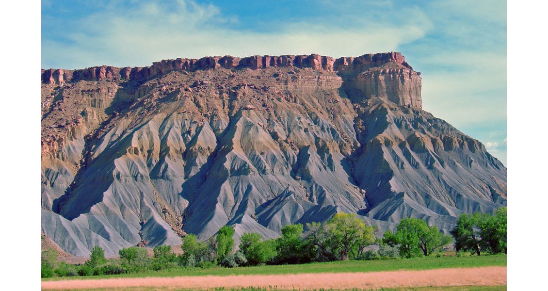
The Mancos Shale in Utah represents an example of thick organic-rich mudstones deposited in mid-Cretaceous times in shallow marine environments in various parts of the world. In this photo from southern Utah the shale is capped by a younger Cretaceous sandstone. Photo: Rasoul Sorkhabi
The New Petroleum
The Cretaceous ended with a severe mass extinction of not only the well-known dinosaurs, ammonites, and rudists but also numerous planktonic species. As the Cenozoic began, biota took time to create new evolutionary paths, and the world entered a generally cooling trend and lower sea levels (which eventually led to the Pleistocene-Recent glaciations). Nonetheless, oscillating sea levels in the Cenozoic resulted in marine regressions and transgressions controlling shallow marine deposition. The oceanic basins formed in the Cretaceous became wider throughout the Cenozoic. If the Cretaceous was a period of break-away and drifting continents, the Cenozoic is characterized by collision of the continents. These tectonic and climatic changes have impacted Cenozoic sedimentary basins.
We have better access to Cenozoic source rocks because of their relatively shallower positions in sedimentary basins. These rocks occur in numerous basins and diverse tectonic-depositional environments, including rift basins (for instance, the Makassar Strait, Gulf of Thailand, and Red Sea), back-arc basins (e.g., Java and Sumatra), strike-slip pull-apart basins (e.g., California basins), foreland basins (such as those of the Laramide Rockies, the Andes, the Alps, the Caucasus, and the Zagros-Bitlis mountains), and lacustrine basins (e.g., the Eocene Green River formation deposited in an intermontane lake in the Rockies). However, the majority of Oligocene-Miocene source rocks are clastic shales associated with large deltaic systems extending from onshore to deepwater. Examples include the Mackenzie delta (Alaska), the Mississippi (Gulf of Mexico), the Orinoco (Caribbean), the Amazon (southern Atlantic), the Niger (West Africa), the Nile (Mediterranean), the Indus (Arabian Sea), the Ganges (Bay of Bengal), the Baram (Sarawak), and the Mahakam (Kalimantan).
Cenozoic source rocks, especially those of the deltaic and foreland basins, predominantly contain kerogen types II and III. While kerogen type III and coaly materials in these rocks suggest gas generation, it should also be noted that not all gas accumulations in the Upper Miocene reservoirs around the world are thermogenic; some of them are actually biogenic gas.
Paleogeographic reconstructions
Six stratigraphic intervals in the Phanerozoic with rich source rocks that have generated over 90% of the world’s conventional oil and gas resources.
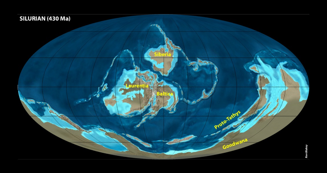
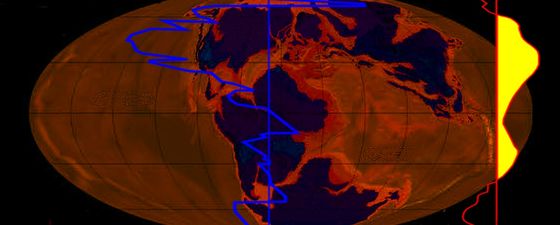
Silurian (430 Ma). (Modified from and courtesy of Professor Ronald Blakey of Northern Arizona University)

Late Devonian (370 Ma). (Modified from and courtesy of Professor Ronald Blakey of Northern Arizona University)

Late Permian (280 Ma). (Modified from and courtesy of Professor Ronald Blakey of Northern Arizona University)
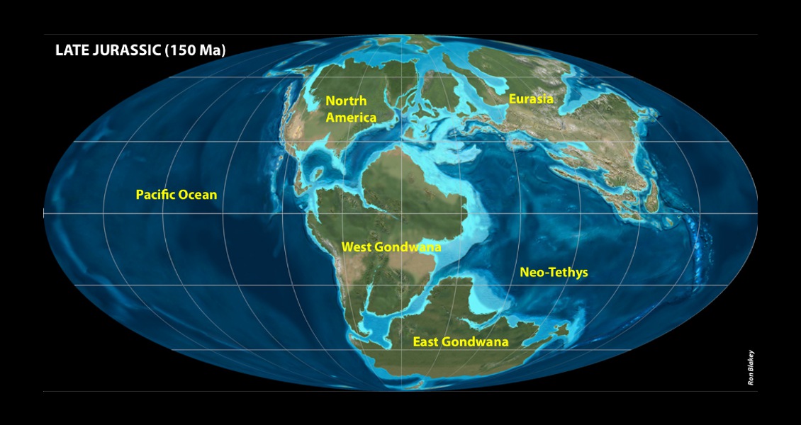
Late Jurassic (150 Ma). (Modified from and courtesy of Professor Ronald Blakey of Northern Arizona University)

Mid-Cretaceous (105 Ma). (Modified from and courtesy of Professor Ronald Blakey of Northern Arizona University)

Early Miocene (20 Ma). (Modified from and courtesy of Professor Ronald Blakey of Northern Arizona University)
Summing Up
(1) In our inquiry into the patterns and causes of rich petroleum source rocks in the geologic record, we have highlighted six intervals on the global scale based on the available knowledge. However, we have treated them as “high trends” in the stratigraphic record rather than clear-cut periods. Individual basins may show similar histories but also variations. Moreover, rich source rocks in the other geologic periods should not be ignored. For example, the Barnett Shale, a prolific gas source in Texas, is of Mississippian age (older than the Pennsylvanian-Permian interval). Similarly the Eocene Green River Shale in the US Rockies and the Cambay Shale in western India are older than the Oligocene-Miocene high. Assessments of global petroleum source rocks will be refined as geochemical data for oil-source correlations become more abundant.
(2) Systematic studies of the stratigraphic distribution of rich source rocks date back to the 1970s and 1980s. Knowledge gained from petroleum exploration and discoveries of the past two decades needs to be incorporated in assessment of global source rocks. These recent discoveries, in places, have actually strengthened the six “highs” in the stratigraphic record (for example the new Cretaceous and Cenozoic discoveries offshore Brazil, West Africa, and East India), but, in other places, have revealed new targets such as onshore discoveries of Latest Proterozoic-Cambrian petroleum in North Africa, India, and Russia.
(3) In this article we mainly dealt with the “deposition” of rick source rocks. Inherent in the geologic record of petroleum accumulations is also the critical time relationship between petroleum generation from source rocks and formation of petroleum traps. This would require a different perspective and analysis.
(4) Here we took into account only conventional oil and gas resources. If oil sands, oil shale, and methane hydrates are also included in the analysis, Cenozoic sediments will dominate the stratigraphic record, and North America will replace the Middle East as the geographic center of hydrocarbons. On the other hand, consideration of heavy oil, tight gas, shale gas, and coal-bed methane may not drastically alter the six stratigraphic highs because of the common source rocks and basins that these non-conventional hydrocarbons share with their conventional counterparts.
(5) A complex set of tectonic, atmospheric, oceanic, and biological processes lead to generation of petroleum. While these processes operate all the time, petroleum resources are not uniformly distributed geographically or in the geologic record. Enormous petroleum resources are concentrated in specific basins and stratigraphic intervals mainly because these regions took advantage of the optimal combination of geological processes responsible for the generation and preservation of petroleum, notably stable sedimentation and high productivity of biota. As a very gross generalization, we note that of the six stratigraphic highs, two of them, namely the late Paleozoic and the Late Cenozoic, are characterized by cold climates, lower sea levels, continental collisions, and deposition of major source rocks in foreland basins and deltaic systems with kerogen types II and III (gas prone). During the other intervals, warm climates and high sea levels favored enormous deposition of source rocks on broad marine platforms.